Gran Fondo New York (May 2013)

(Editor’s note: This event took place in May 2013 but I’m writing this in September 2023. Why wait 10 years I hear you ask? Well, I’ve just ridden the Gran Fondo Maryland, another similar event, which reminded me about this New York one. So I found the old photos in a dusty Facebook album and decided to post them here. 10 years between Gran Fondos! Hopefully, it won’t be as long until the next one 😉)

Event: Gran Fondo New York
Distance: 105 miles
Ascent: 7,000ft ascent
Time: 6 hrs 56 mins
Position: 840th overall out of 5,000 cyclists
Age Category Position: 280th in the 18 – 39 category

The route began in Manhattan, well, the middle of the Hudson to be precise, on the George Washington bridge. From there we headed upriver along the banks of the Hudson, up to Bear Mountain State Park for an out-and-back up the mountain. Then we followed a more inland route over rolling hills on the return back to the finish at the Weehawken waterfront park.

New York baby! 🥳
Signing in on the day before the race
Checking out the route, but ignoring the spiky course profile for now 😎
4am alarm call to get to the start line. Still smiling and no idea how cold it would be!
The race starts from the middle of the iconic George Washington Bridge
It was freezing cold waiting for the race to begin. I totally underestimated it!
Wave after wave of green clad cyclists early in the race
Did I mention that the weather was grim that day? Looking back down the Hudson in the direction we started earlier that morning.
Nature calls
The roads around Bear Mountain State Park were awesome, especially in the misty conditions
A crowd at the top of Bear Mountain! The energy and enthusiasm of the day were awesome!
Proof I made it!
Descending Bear Mountain
Super fun (and cold) descent
I appear to be going the wrong way! Bear Mountain ascent/descent was an out-and-back, so people were on the way up as I went down.
Somehow still smiling, maybe because I know the finish is close
The finish line! Raining a wee bit.
It was hammering down as I finished
Official photo crossing the finish
I was so cold at this point. Shivering uncontrollably. But still smiling! Fantastic day on the bike!
Finishers swag
The edible finishers swag.

A walk in the woods II: Shenandoah National Park 2013

After the success of last year’s inaugural Spring walking trip to the Shenandoah, and with family members visiting from the UK again, it was time for the 2nd Annual Spring walking weekend in Shenandoah National Park. This year our merry party consisted of yours truly, my girlfriend Alexis, my mum and her boyfriend, Dave. After a busy start to the year, with little opportunity to escape the city (apart from an early trip to Cape Town), I was yearning to get back to basics and immerse myself in nature again.

Shenandoah1311

View west from the Jewell Hollow Overlook

Day 1: Cedar Run Falls and Whiteoak Canyon Falls loop

Walks in the Shenandoah National Park still feel novel to me, a sort-of upside-down walk for someone accustomed to starting out at the base of a mountain and ascending to the summit. Thanks to the scenic Skyline Drive, a 105 mile road along the rooftop of the National Park, most walks begin at the high point of the day before descending off the ridge.

Sure enough, today’s walk began at the day’s highest point, before descending the steep and wild Cedar Run canyon, passing cascade after cascade, and culminating in the Cedar Run Falls itself, our “summit”, if you will. Of course, reaching the “summit” necessitated a lunch stop (a habit from UK hillwalking days where folklore has it that on any given hill in Britain, in any weather, at any time of the year, one will find a fellow walker proclaiming how pleasant it is whilst tucking into a home made sandwich). Our return route climbed gently up Whiteoak Canyon, where there are a number of impressive waterfalls and good views.

Shenandoah1302

Descending down Cedar Run Canyon

Shenandoah1304

Frequent river crossings were the order of the day

Shenandoah1303

We weren’t the only ones enjoying the sunshine – a Northern Water Snake catching some rays. I seem to average one snake sighting per trip at the moment – Australia 2012 and Shenandoah 2012

Shenandoah1305

Waterfall in Cedar Run Canyon I

Shenandoah1306

Waterfall in Cedar Run Canyon II

Shenandoah1307

Toothed mushroom – Sarcodon imbricatus – in the undergrowth

Shenandoah1308

Yellow Poplar – Liriodendron tulipifera – trees along the trail

Shenandoah1309

A hop, skip and a jump and you’re across

Shenandoah1310

Cedar Run Falls – check out Lexi in the bottom right corner for idea of scale

Day 2: Knob Mountain and Jeremys Run Loop

A longer 12 mile loop traversing the ridge of Knob Mountain and returning along the valley floor, with frequent river crossings of Jeremys Run. It felt like we had the park to ourselves today; it wasn’t until we hit Jeremys Run that we saw another soul. Up on the ridge of Knob Mountain we saw plenty of (fresh) bear scat. We were all excited (and slightly nervous) by the prospect of a potential bear sighting but sadly they remained elusive on this occasion.

Shenandoah1314

The closest we came to a “view” from the wooded summit of Knob Mountain

Shenandoah1313

Robust marker posts pointed the way

Shenandoah1312

Synchronised on the balance beam, crossing Jeremys Run for the 37th time* (*best guess)

Shenandoah1315

Jeremys Run

Day 3: Hazel Falls

A shorter, rainy walk to visit Hazel Falls, described as a suitable inclement weather destination on account of the large cave next to the falls. I can attest to it being a dry and welcoming harbour from the elements.

Shenandoah1316

Lexi still smiling despite the rain

Shenandoah1319

The team with Hazel Falls in the background

Shenandoah1320

Hazel Falls I

Shenandoah1321

Hazel Falls II

Hiking in Cape Town

Since my last update on this blog, we’ve seen North Korea conduct its third nuclear bomb test, witnessed a major meteor strike and seen a new pope elected. A dramatic start to the year!

Earlier this year I was fortunate to spend a week in beautiful Cape Town for a good friend’s wedding and managed to get in a couple of decent treks whilst there. I didn’t take my big camera so all the photos below are taken on an iPhone with a little bit of post processing in iPhoto. I’m loving the portability of a phone camera and the quality is getting pretty good nowadays.

A delayed journey saw me making an impromptu connection in my former home city of London – it was a spectacular sight to fly over:

IMG_2229

Hike 1: Table Mountain via the India Venster route

Free from the office and near a mountain? Well let’s climb it then! At the trailhead with my good climbing buddy Steven (of South America and Alps fame) and girlfriend Lexi (who has no idea yet what lies ahead 😉 )

IMG_2261

I can’t say we weren’t warned…

IMG_2282

Spectacular view of Lion’s Head as we get higher up Table Mountain. It was a beautiful day. I got the impression that every day is like this in summer!

IMG_2292

We ended up slightly (ok, very far) off route and were picking our way gingerly around the cliffs. We pushed on thinking we could take a short cut back to the path but there was a final barrier – a steep cliff that was too dangerous to down climb – blocking our way. Back it was then. Better a live donkey than a dead lion!

IMG_2309

I’d still rather take the trail any day of the week:

IMG_2311

Back on the official route and enjoying the “climbing” section – a mini via ferrata:

IMG_2328

The views from the summit down to Camps Bay were stunning:

IMG_2372

Duly noted! (this sign was at the top of the climbing path route we came up but we were taking a different path down, which although less direct, was more mellow)

IMG_2353

It still had the occasional steep section and ladder to negotiate:

IMG_2389

Late evening sun on the descent (a panorama stitch on the iphone):

IMG_2402

We had a full day on the mountain, from 9 until sundown at 8.30. From there it was a race to the nearest cheap and cheerful Italian restaurant to satiate our gnawing bellies. Sunset near the trailhead:

IMG_2420

Hike 2: Lion’s Head

IMG_2530

iPhone panorama of the trail up Lion’s Head, with Camps Bay and Table Mountain in the background. It was another stunning day with spectacular views.

IMG_2535

Another steep band to climb using the chains and steps in the rock. Adds a little bit of excitement to the walk:

IMG_2541

Nearing the summit with Table Mountain in the background:

IMG_2542

Lexi on the summit:

IMG_2546

Yours truly enjoying the setting

IMG_2556

iPhone panorama from the summit showing how extensive the Table Mountain massif is:

IMG_2560

Early Exploration of the Interior of Australia (Larapinta Trail Part Three)

This is third part of a three-part series about a thru-hike with my brother of the stunning Larapinta trail. Part one, the story of our trek, can be viewed here and part two, photos from Standley Chasm, here.

The country ahead, Larapinta Trail, Australia

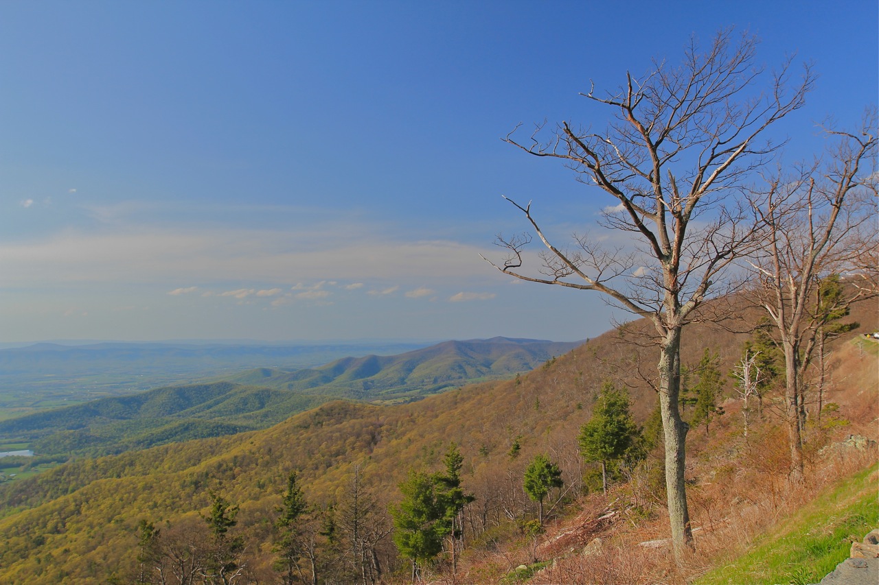
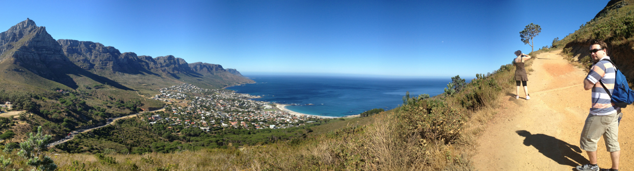
The country ahead, from the summit of Brinkley Bluff, Larapinta Trail, Australia

John McDouall Stuart, a small but incredibly tough Scotsman, led the first successful expedition to cross Australia from south to north and back again, traversing the then blank interior of Australia. He named the West MacDonnell range, the very range that we had spent 8 days crossing as we walked the Larapinta Trail; he named and was the first to climb Brinkley Bluff, a mountain that we climbed along the way; heck, there is even a pass through the mountain range named after him. In short, walking the Larapinta trail is to take a journey back in time to discover the lands and people that played a formative part in the exploration and development of the Australian continent.

Stuart's Pass, Larapinta Trail, Australia

Stuart’s Pass, Larapinta Trail, Australia

After the trek I bought a recently reprinted copy of Stuart’s 1861 Expedition Diary. It is a compelling tale of a journey full of serious hardships and genuine first-hand geographical discoveries. The mention of Brinkley Bluff really brought his journey to life for me – we had also climbed that mountain only a week earlier:

THURSDAY, February 27. [1861] – Owen’s Springs. This morning the clouds all cleared away without any rain. Proceeded up the Hugh [river] to the north-east side of Brinkley’s Bluff. I have been obliged to leave one of the weak horses behind. Three more have given in to-day, and it was as much as we could do to get them here.

Summit of Brinkley Bluff, Larapinta Trail, Australia

On the summit of Brinkley Bluff which was climbed by the early explorer John Stuart during his explorations of the interior of Australia

He probably stood in some of the same places that my brother and I did, seeing an almost identical landscape (nothing man-made is visible from the summit except for the cairn and the trail obviously, and one distant jeep track).

For the information of His Excellency the Governor-in-Chief, I have the honour to report to you my return to Adelaide, after an absence of twelve months and thirteen days; and I herewith beg to hand you my Chart and Journals of the Expedition, from which I have just returned. – John McDouall Stuart, Explorer, from his 1861-2 Expedition Diary

After an absence of only eight days, I returned to Adelaide having taken the considerably quicker and easier option of a flight back from Alice Springs. Whilst staying in Adelaide with my relatives, I took a trip to see the State Library. Incredibly, the library had an exhibition wall displaying memorabilia, maps and books from the Stuart expeditions. It was fascinating to learn more about his journeys and lifetime of work to open up the interior. I delighted in recognizing place names where I had been trekking only a week earlier; places he had named as he laid eyes on them for the first time. It was enthralling.

Adelaide State Library

The magnificent Adelaide State Library

The serendipity didn’t end there however. The Royal Geographical Society of South Australia is housed on the third floor of the State Library and their door was open. A staff member warmly invited us in to have a look round. The large room was a haphazard explosion of maps, old books, objects of exploration, photographs and who knows what else. Like a kid in a candy shop, I excitedly scanned the room trying to take it all in. In one corner was a statue of John Stuart himself. At his feet was a piece of the dig tree from the ill-fated Burke and Wills expedition.

Statue of John Stuart, Explorer, in the Royal Geographical Society of South Australia

Statue of John Stuart, Explorer, in the Royal Geographical Society of South Australia

“Do you want to see any of the maps?” asked the volunteer librarian.

“Yes, I’d love to. I’ve just come back from the West MacDonnell ranges, so maybe we can find a map of that area.”

After rummaging through the filing cabinet, he found a facsimile 1886 map of the area west of Alice Springs. Lo and behold! There were names I recognized on this map. Campsites, peaks, ranges from my recent Larapinta trek were marked this ancient map.

Old facsimile maps, Royal Geographical Society of South Australia

Old facsimile maps, Royal Geographical Society of South Australia

Old facsimile map, Royal Geographical Society of South Australia

Old facsimile map, Royal Geographical Society of South Australia

Redbank Gorge, Sonder Mountain, Rockybar Creek, Glen Helen Station, Mt. Giles, Fish Waterhole, Ellery’s Creek, Chewings Range… All names that we had discussed, passed, climbed or camped at only a week earlier.

Old facsimile map showing the area where the modern-day Larapinta Trail runs

Old facsimile map showing the area where the modern-day Larapinta Trail runs

Old exploration tomes, Royal Geographical Society of South Australia

Old exploration tomes, Royal Geographical Society of South Australia

I wonder how John Stuart must have felt as he opened up this country and saw these views for the first time. Did he allow himself to smile at the beauty of it all? Or was he consumed by the task at hand, constantly breaking trail and searching for his next source of water? To be an explorer, now that’s the life!

Larapinta Trail, Australia

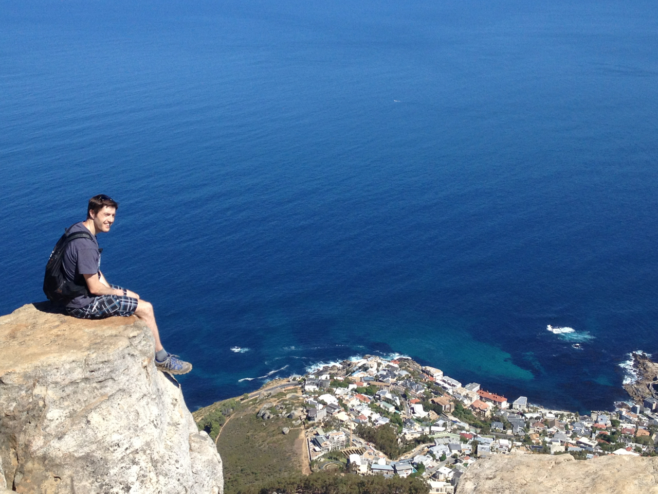
Surveying the land ahead on the Larapinta Trail, day 5

Standley Chasm (Larapinta Trail Part Two)

This is part two of a three-part series about a thru-hike with my brother of the stunning Larapinta trail. Part one can be viewed here. Part three, a post for the explorer-buffs amongst you, is coming soon.

Standley Chasm is one of the standout geological features of the West MacDonnell mountain range. It lies close to the trail, so on the morning of day 7 of our trek we took a side trip to see it. The soaring red walls, some 80 metres high, were well hidden until we turned the final corner of the walk in. We stopped in our tracks, craning our necks to take in their full height, in awe of the forces that created such a feature. No one else was there, just me and my brother standing transfixed between those red walls. It was one of those moments that’ll stick in mind; one of the highlights of our time in this beautiful part of the world.

Entering Standley Chasm

Entering Standley Chasm, West MacDonnell Range, Australia

Standley Chasm, West MacDonnell Range, Australia

Standing in Standley Chasm, West MacDonnell Range, Australia

Standley Chasm, West MacDonnell Range, Australia

Looking back at the entrance to Standley Chasm, West MacDonnell Range, Australia

Credit to my brother for taking the second shot in this set.